PWG - Actualidad
en Geofísica
HOME | Free
E-book
|
|
Noviembre de 2025 The identification of seismic precursors remains a fundamental challenge. Foreshocks are often indistinguishable from regular seismic sequences, making it difficult to determine whether they precede a larger rupture. We show that the ground velocity envelope recorded after several Mw6+ foreshocks exhibits an anomalous sawtooth pattern, distinct from typical post-mainshock signals. This pattern suggests the presence of rate-weakening fault |
patches approaching instability, promoting stress transfer and aftershock migration into neighboring critically stressed regions. A similar signature was observed in multiple events, including the 2011 Mw9.1 Tohoku earthquake and the 2014 Mw8.1 Iquique sequence. To assess the systematic occurrence of this anomaly, we introduce an index Q based on the first 45 min of waveform data. Analyzing 68 M6+ earthquakes in selected regions since 2011, we find that 10 of 11 foreshocks preceding a larger event exhibit anomalous Q values, while only 4 of 57 other events show similar behavior. These findings suggest that foreshock waveform characteristics may provide insight into seismic rupture processes. |
Noviembre de 2025 Widely used geomagnetic activity indices like Kp or Dst, derived from the combined data from several observatories distributed worldwide, are crucial to forecasting since solar-driven geomagnetic activity can significantly affect technology and human activities on Earth and in near-Earth space. We developed a new model to forecast geomagnetic indices by incorporating predicted data from |
individual observatories. Unlike previous models that rely solely on an index and overlook local physical effects, our approach accounts for each observatory separately in the forecasting process, allowing for index predictions that integrate the same physical principles as in the original calculations of the index. We demonstrate the model's performance for Kp and the newer Hpo indices (Hp60 and Hp30), which measure planetary disturbances with higher resolution than Kp and without its upper limit of 9. The model demonstrates good agreement, accurately capturing trends and overall behavior, even with sparse solar wind data. |
Noviembre de 2025 Anthropogenic activities like fluid injection can increase pore-pressure and induce seismicity. Variations in the b-value (slope of the frequency-magnitude distribution) of induced and natural seismic events are thought to reflect the stress state, although recent laboratory results suggest that fault roughness also contributes. In nature, stress, fault roughness, and pore-pressure effects |
can rarely be disentangled. Here, we investigate these effects and their relative contributions to b-value variation in the laboratory and compare them with hydro-shearing in Enhanced Geothermal System reservoirs. Spatial-temporal variations in b-values stem from three distinct factors: (a) Increasing differential stress shows an inverse linear relationship with b-value, with a steeper slope at high pore pressure. (b) Higher pore-pressures, on average, lead to lower b-values. (c) Spatial variations during injection are potentially structurally controlled so that high-damage zones promote higher b-values. We conclude that b-value variations outside the lab require cautious interpretation because of these multiple underlying causes. |
Noviembre de 2025 Oceanic ridges often collocate with seismic barriers and episodic aseismic slip. However, how subducted seafloor topography drives interactions between slow and fast slip remains unclear. Here, using GNSS, InSAR and seismicity, we show interactions between a deep slow slip event (SSE) and a nearby shallow earthquake sequence that occurred in 2020 in northern Chile. These events |
overlap with the subducted Copiapo ridge, which has served as a barrier for historical earthquake ruptures. Gravity field data and seismic tomography reveal that the SSE nucleated in a region hosting a subducted seamount. Six months later, the seismic sequence dynamically triggered the acceleration and migration of the deep SSE, while afterslip and aftershocks propagated up to another subducted seamount at shallower depth. Our findings suggest that subducted seamounts influence fault hydromechanics, where high pore-pressure and rate strengthening material promote continuous slip release, reducing slip deficit. This process is modulated by SSEs and low magnitude seismic sequences. |
Octubre de 2025 Geodetic observations along convergent margins have achieved unprecedented resolution in detailing deformation associated with earthquake cycles. A comprehensive understanding of how to best interpret these data for forecasting remains crucial. Here, we combined analogue seismo-tectonic models of a megathrust and Explainable Artificial Intelligence (XAI) to characterize the link between earthquakes and deformation. We utilized |
deformation features to train convolutional neural networks (CNN) that forecast the time left before a laboratory earthquake. We then used Integrated Gradients (IG), an XAI technique, to identify areas and features contributing to model forecasts. CNNs perform better compared to decision trees utilizing sparse point-wise features highlighting the importance of spatial patterns. IG reveals the significance of trench-perpendicular deformation downdip the rupturing asperity, trench-parallel deformation inland, and local deformation curl, in forecasting rupture timing. These emphasize the need for dense networks to monitor deformation and suggest patterns that may signify rupture imminence in convergent margins. |
Septiembre de 2025
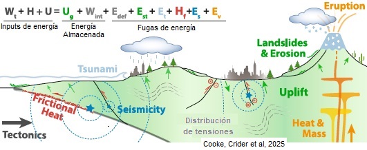
Subduction zones are host to some of the largest and most devastating geohazards on Earth. The magnitude of these hazards is often measured by the amount of energy they release over short periods of time, which itself depends on how much stored energy is available for the geologic processes that drive these hazards. By considering the energy transfer among processes within subduction zones, we can identify the energy inputs and outputs to the system and estimate the stored energy. Due to the multiscale nature of subduction zone processes, developing an energy budget of subduction zone hazards requires integrating a wide range of geologic and geophysical field, laboratory, and modeling studies. We present a framework for developing mechanical energy budgets of upper crustal deformation that considers processes within the magmatic system, at the subduction zone interface, distributed and localized deformation between the arc and trench, and surface processes that erode, transport, and store sediments. The subduction energy budget framework provides a way to integrate data and model results to explore interactions between diverse processes. Because fault mechanics, sediment transport and magmatic processes within subduction zones do not act in isolation, we gain insights by considering the common energetic elements of the subduction zone system. Building energy budgets reveals gaps in our understanding of subduction zone processes, and thus highlights opportunities for new interdisciplinary research on subduction zone processes that can inform hazard potential. |
|
Agosto de 2025 Comparisons between observed and model-resolved gravity waves (GWs) are crucial for evaluating general circulation model (GCM) simulation accuracy and understanding wave characteristics. However, observational noise often obscures waves, complicating such comparisons. To address this, we have developed a GW detection method using a convolutional neural network (CNN). The CNN is trained on Atmospheric Infrared |
Sounder (AIRS) temperatures with labels indicating wave presence based on Berthelemy et al.. Their method detects noise-induced pixel-to-pixel variations in horizontal wavelengths; in contrast, the CNN robustly identify waves even when applied to smoothly varying model data. Using this method, we compare stratospheric GWs in boreal winters between AIRS observations and a high-top GW-permitting GCM, Japanese Atmospheric GCM for Upper Atmosphere Research (JAGUAR). The results agree well and exhibit similar interannual variability, with discrepancies also identified, including a more zonally elongated distribution of tropical GWs in JAGUAR. This method is broadly applicable to the future use of satellites for guiding wave-resolving atmospheric model development. |
Julio de 2025 Hydrothermal explosions are one of the geological hazards most likely to impact people in Yellowstone National Park, but their frequency is poorly known. Infrasound and seismic sensors identified an explosion in Norris Geyser Basin on 15 April 2024, at 14:56 MDT (20:56 UTC)—the first instrumentally detected hydrothermal explosion in the Yellowstone |
region. The event affected an area tens of meters across, resulting in fractured ground, a shallow explosion crater, and a field of ejecta. There were no immediate geophysical precursors, but in the preceding years elevated discharge of thermal water altered the color, temperature, and level of a nearby small lake. Expanded seismo-acoustic monitoring in Yellowstone National Park could be useful for detecting small hydrothermal explosions and constraining their frequency, magnitude, energy release, and locations—information that could be used to better assess and mitigate hazards for the millions of people that visit the park each year. |
Junio de 2025 Widely used geomagnetic activity indices like Kp or Dst, derived from the combined data from several observatories distributed worldwide, are crucial to forecasting since solar-driven geomagnetic activity can significantly affect technology and human activities on Earth and in near-Earth space. We .developed a new model to forecast geomagnetic |
indices by incorporating predicted data from individual observatories. Unlike previous models that rely solely on an index and overlook local physical effects, our approach accounts for each observatory separately in the forecasting process, allowing for index predictions that integrate the same physical principles as in the original calculations of the index. We demonstrate the model's performance for Kp and the newer Hpo indices (Hp60 and Hp30), which measure planetary disturbances with higher resolution than Kp and without its upper limit of 9. The model demonstrates good agreement, accurately capturing trends and overall behavior, even with sparse solar wind data |
Junio de 2025 The chemical composition of marine sedimentary pore waters, notably freshening signals inferred from decreases in dissolved Cl−, have demonstrated a link between methane hydrate accumulation and the circulation of fluids and gases in convergent margin systems. However, the south-central Chilean Margin (32–46°S) lacks geochemical evidence for this relationship. In 2019, D/V JOIDES Resolution Expedition 379T drilled two sites (J1005 and J1006) near legacy site ODP 1233 (41°S) and recovered 120 m sediment cores from a seafloor venting structure. The sites are less than 10 km apart but exhibit differences in pore water chemistry and methane hydrate occurrence. The extent of Cl− decrease is a function of distance from |
the venting structure, with the greatest freshening (and only recovery of methane hydrate) occurring at the closest site. Methane fluxes follow the same pattern, suggesting a common influence. Increasing oxygen and decreasing hydrogen isotopes point to mineral bound water originating ∼2.5 km below the seafloor as the primary source of pore water freshening. In contrast, marine silicate weathering coupled to methanogenesis, authigenic carbonate formation, and the alteration of oceanic crust regulate Sr systematics. These spatial heterogeneities indicate that fluid migration is attributable to regional overpressures in the accretionary complex and flows along narrow fault structures. We suggest that the focused migration of deep, gas-charged fluids serves as a model for regional methane hydrate accumulation, reconciling model estimates and field observations. Collectively, our results highlight an important link between regional hydrogeology, diagenetic processes, and methane hydrate formation on the south-central Chilean Margin. |
Mayo de 2025 Smoke emissions from fire activities have serious impacts on the environment and public health. Air quality forecast (AQF) models are often used to understand such impacts by simulating fire behaviors, resulting emissions, and air quality predictions. Most AQF models rely on satellite fire detection products as the source of fire characteristics (e.g., location and intensity) and |
assume persistent fires without time-varying fire behaviors. Hence, this study presents a new machine learning based fire spread forecast model, the Fire Intensity and spRead forecAst (FIRA), which could improve the performance of AQF models by providing the predictions of future fire location and intensity. Overall, FIRA accurately represents future fire location while generally underestimates fire intensity compared with near-real-time satellite fire products. The underestimation can be fixed by applying simple scaling factors to FIRA products. Using the scaled FIRA products as the source of fire characteristics in AQF models can improve the air quality prediction, surface fine particulate matter (PM2.5) concentrations for example, affected by fires. |
Mayo de 2025 The constitutive behavior of faults intervenes in virtually every aspect of the seismic phenomenon but is poorly understood, particularly regarding how effective normal stress affects the boundaries of the seismogenic zone. Here, we explore the mechanical properties of Pelona schist, Westerly granite, .phyllosilicate-rich gouge, gabbro, hornblende, |
lawsonite blueschist, montmorillonite, and smectite in hydrothermal conditions at various confining pressures and explain the laboratory observations with a physical model of fault friction. The thermobaric activation of healing and deformation mechanisms explains the boundaries of unstable slip as a function of slip-rate, temperature, and effective normal stress for a given lithology. The constitutive law affords extrapolation of laboratory data in the conditions relevant to seismic cycles throughout the crust, explaining the focus of large earthquakes in collision, subduction, and continental and oceanic transform settings |
Mayo de 2025 Solar flares are bursts of electromagnetic radiation originating in the Sun's atmosphere. Solar flares cause a rapid increase in ionization in the ionosphere, resulting in radio signal interference. This paper aims to predict the ionospheric response to the solar flare of various characteristics in all latitudes around the dayside ionosphere. X-ray flux measured by the Geostationary Operational Environmental Satellite (GOES) satellite associated with 84 solar flare events between 2000 and 2017 are obtained. Global total electron content (TEC) data from more than 5,000 ground Global Navigation Satellite System receivers are used. The rate of the TEC Index (Rate of TEC Index (ROTI)) is |
calculated to examine the time evolution of ionospheric response. Three selected events are studied in detail by eliminating the ROTI associated with stations on the nightside. A nonlinear response of the ionosphere associated with solar flare characteristics including rise/fall time and maximum amplitude is discussed. The first global machine learning (ML) model to predict solar flare impact on Earth's ionosphere through ROTI parameter is developed. Solar flare parameters measured by the GOES satellite along with solar radiation angle and ROTI data from 5-degree latitude ranges are selected as an input to the ML model. Thek-nearest neighbors and random forest algorithms are used. Quantitative and qualitative results show that the random forest provides better accuracy in predicting the time evolution of ionospheric response to X-class solar flare. The coefficient of determination ( ) and the Pearson Correlation Coefficient (r) are used to provide a quantitative comparison of the model prediction with the actual data. |
Mayo de 2025 Above a magnitude of completeness
, all earthquakes are considered to have been detected, and the frequency distribution of earthquakes per unit of magnitudes follows an exponential law, known as the Gutenberg-Richter law, whose exponent is the so-called. The study of the spatio-temporal variations of x
has attracted much attention in recent years. In particular, it is thought to vary with increasing stress state and has recently been |
proposed to discriminate foreshock sequences. Therefore, a robust estimation of its variations and uncertainties is needed. In this paper, we present a new method, called b-Bayesian, to properly estimate the temporal variations of x within a probabilistic framework. The b-Bayesian method has the following advantages: (a) it uses all available earthquake data from an earthquake catalog without the need to truncate them above the completeness magnitude, (b) it jointly considers the temporal variations of detectability and x , and (c) it operates within a Bayesian framework. As a first application, we chose an earthquake catalog from far-western Nepal with significant variations in detectability. We compared the full probability distributions obtained with our new approach with maximum likelihood estimates from classical approaches. |
Mayo de 2025 Due to geomagnetic activity causing significant variations in atmospheric density, low-orbit satellites may be unable to maintain normal operations. Forecasting geomagnetic activity with a longer lead time has become crucial, as it allows satellites ample time to adjust their positions. Current physical models excel in forecasting 3-day geomagnetic disturbances by initializing the model from the solar corona. However, this method is highly time-consuming, making it potentially |
unsuitable for rapid orbital adjustments. Therefore, we use faster computational machine learning (ML) models to address this issue. We propose a new ML approach that enables the model to learn more comprehensive information from the solar corona. We incorporate parameters related to the coronal structure as inputs, including the magnetic field structure of the corona and the brightness and area of coronal holes. Additionally, we introduce the Integrated Gradients method to extract the propagation characteristics of the solar wind from the model, enhancing its reliability. We evaluate the model performance from multiple perspectives, demonstrating that this method effectively improves the accuracy of geomagnetic activity predictions for the next 2–3 days. With continuous improvements in data quality and model structure, this method holds promise for developing a model suitable for operational forecasting in the future. |
Abril de 2025 The Extremely Low Frequency band (ELF: 0.03–1,000 Hz) electromagnetic signals from thunderstorm lightning discharges can propagate around the globe in the Earth-ionosphere resonance cavity and thus be used for ionosphere monitoring. We use ELF observations of impulses detected by the World Wide Lightning Location Network (WWLLN) to investigate ELF propagation velocity and arrival azimuth under diurnal changes |
over 2 days in September 2023. Also, temporary effects of solar flares' ionizing fluxes are monitored, leading to increase of the ELF signal propagation speed in proportion to the X-ray flux intensity. We present a simple method for automatic and large-scale analysis, utilizing data from two registration systems (our ELF reciever and WWLLN) and enabling easy evaluation of changes in wave propagation speed. Comparative analysis of WWLLN identified impulses generated in Africa and America reveals varying effects of signal refraction, with increased azimuth changes for signals propagating across the ionospheric ionization gradients associated with the day/night terminator. The method has a potential to become a standard tool for the analysis and monitoring of the lower layers of the ionosphere. |
Abril de 2025 The accretion of Earth and the formation of a metallic core released a large amount of primordial heat and may have enabled its evolution into a habitable world. Metal-silicate segregation likely occurs in super-Earth exoplanets as well, but its influence on their initial thermal states has not been fully examined. Here we calculated the energy released during core-mantle differentiation of super-Earths for a range of planet radii and core mass |
fractions. We found that the energy of differentiation increases with planet mass for rocky planets with Earth-like composition, and it peaks at 55% core by mass in Earth-sized rocky planets. Using the latest mineral physics constraints on the equations-of-state and melting curve of relevant phases, we modeled the initial thermal profiles and assessed the extent of melting in initial iron cores for plausible heat retention efficiencies. Our results suggest that following accretion and metal-silicate differentiation, the cores of most super-Earths are expected to be at least partially molten, a necessary condition for the generation of a magnetic field. Based on the largely molten state of Earth's core at the present day, we place a lower bound of 7% retention of accretional energy as primordial heat in rocky planets. |
Abril de 2025 Enceladus' ocean could support methanogenic life in terms of the availability of chemical energy (H2 and CO2) and nutrients (N and P). However, excess energy and nutrients in the ocean raise the question of why they remain abundant if Enceladus is inhabited. Terrestrial methanogens require trace metals, such as Co, Ni, Cu, Zn, and Mo, for their enzyme activation; nevertheless, the availability of these trace metals is largely unknown in Enceladus' ocean. Here, we investigate concentrations of dissolved trace metals in Enceladus based on hydrothermal experiments and thermodynamic equilibrium calculations in order to understand the |
minerals that control their concentrations in water-rock interactions. Our results show that Ni and Co concentrations in hydrothermal fluids can be controlled by dissolution of a sulfide mineral, pentlandite, in chondritic rocks. In a pH range for Enceladus' ocean, our calculations show that hydrothermal environments would be the source of dissolved Ni and Co. Given a suggested range of water chemistry (pH and dissolved species) of Enceladus' ocean, Ni, Zn, and Mo concentrations in hydrothermal fluids would be comparable to the levels required for terrestrial methanogens. However, both Co and Cu concentrations would be depleted compared with the levels required for terrestrial methanogens. We suggest that if methanogenic life in Enceladus requires trace metals at the same levels as for terrestrial methanogens, the availability of Co and Cu could control the activity of methanogenesis, possibly leaving excess chemical energy and nutrients in the ocean. |
Marzo de 2025 The occurrence frequency and catastrophe caused by flooding are increasing rapidly, highlighting the importance of real-time impact-based forecasting. However, traditional approaches primarily based on hydrodynamic models need large computational cost and generally fail to achieve real-time flood mapping, especially for large-scale watersheds. In this work, a novel, simple and convenient approach called Topography-based Flood Inundation Mapping (TOPFIM) is developed to achieve rapid and accurate flood mapping. TOPFIM is characterized by an adaptive river segmentation method and a |
dynamic inundation volume allocation approach adhering full water volume constraint. The proposed approach is applied to the upper reaches of the Le'an River basin, China, and HEC-RAS is employed as the benchmark for comparison. The results demonstrate that TOPFIM's simulation accuracy for inundation extent approaches that of hydrodynamic models, with an averaged critical success index of 0.83 and hit rate of 0.90 compared to HEC-RAS's simulation. Moreover, TOPFIM generates flood inundation mapping prediction within 10 s rather than hours required by conventional hydrodynamic models. It signifies a pivotal practical enhancement that has the potential to effectively preserve lives and protect assets in times of flood emergencies. Overall, as a simple and convenient tool, TOPFIM demonstrates its potential for real-time flood inundation mapping and risk analysis. |
Marzo de 2025 There are still significant differences in the evaluation of the enhancement of absorbance of BC particles, which lead to large uncertainties when estimating their climate effects. Morphology of BC aggregates is one of the key factors that influence their light absorbance. The BC fractal dimension is the most important factor that can be used to describe the BC morphology and can be employed in the model to estimate its optical properties. However, the can not be measured online, making it |
hard to study the evolution of BC light absorption properties due to the transformation of BC morphology during the atmospheric aging processing. In this study, we propose a novel method to measure BC's with an accuracy of 0.08 ± 0.07 by theoretically establishing the relationship between BC's mobility diameter, and mass concentration. Field measurements show that the ambient BC ranges between 2.14 and 2.41 at a suburban site in China. The variations of were consistence with the aging processing of BC aggregates. Our proposed method makes it possible to track the atmospheric BC morphology evolution and constrain the BC optical and radiative properties based on the online measurement of the BC. |
Marzo de 2025 Seismic noise measurements have been used as an effective monitoring tool for groundwater changes. However, the lack of sufficient groundwater well deployment hinders direct constraints to seismic measurements. Here, we |
aim to compare 12 years of seismic monitoring with hydrologic recordings from surface water stations, which not only have a widespread distribution but also serve as an approximation of the groundwater level. In addition to presenting highly consistent measurements in the Yellowstone National Park, we also integrate a straightforward conceptual model and physical mechanisms to support our observations. Our results demonstrate the possible implementation of seismic-groundwater monitoring in complex watersheds, where direct groundwater measurements are difficult to collect. |
Febrero de 2025 Deep learning models have been extensively applied to various aspects of hydrogeological modeling. However, traditional approaches often rely on separate task-specific models, resulting in time-consuming selection and tuning processes. This study develops an integrated Latent Diffusion Model (LDM) framework to address four key hydrogeological modeling tasks: aquifer heterogeneity structure generation, surrogate |
modeling for flow and transport, and direct inversion of aquifer heterogeneity structure. Using a consistent architecture and hyperparameters, the LDM demonstrates robust multi-task processing capabilities, accurately capturing aquifer heterogeneity, enabling rapid predictions of hydraulic head and solute transport, and efficiently performing direct inversion without iterative simulations. By integrating multiple tasks within a single framework, LDM eliminates the need for task-specific models or extensive parameter optimization, offering an efficient and adaptive general solution for deep learning-based hydrogeological modeling. Its generalization across diverse objectives underscores its potential as a cornerstone for advancing Artificial General Intelligence in hydrogeological modeling. |
Enero de 2025 An earthquake doublet occurred in Turkey on 6 February 2023, with propagating Rayleigh waves triggering perturbations in the ionospheric total electron content (TEC) for both the M 7.8 earthquake (EQ7.8) and the M 7.5 earthquake (EQ7.5). A discrepancy between the velocities of TEC perturbations and Rayleigh waves has been noted, but its causes remain unresolved in previous studies. In this study, we calculated the velocities of TEC perturbations and the frequency-dependent |
velocities of Rayleigh waves, considering their intrinsic dispersive characteristics. To retrieve TEC, we utilized ground-based Global Navigation Satellite System (GNSS) data from geostationary Earth orbit (GEO) satellites to mitigate the effects of moving ionospheric pierce points (IPPs) from orbiting satellites. The results reveal that the velocities of TEC perturbations ( 2.60 km/s for EQ7.8 and 2.77 km/s for EQ7.5) do not align with the velocities of Rayleigh waves across the entire frequency band (2.4–3.0 km/s for EQ7.8 and 2.6–3.5 km/s for EQ7.5). However, they are comparable within specific periods of 10–30 s due to dispersion effects for both EQ7.8 and EQ7.5. The dispersive Rayleigh waves, which exhibit significant amplification in the 10–30 s period range, are identified as the primary source of the pronounced coseismic TEC perturbations, particularly for EQ7.5. |
Enero de 2025 The correlation between subduction zone features and megathrust seismicity provides relevant clues on what controls the generation, location and clustering of mega-earthquakes (magnitudes Mw ≥ 8.0). Thus far, weak correlations are found between subduction zone parameters and seismicity through bivariate statistical analyses. Here, we used Explainable Artificial Intelligence (XAI) to assess the relevance of geophysical properties and tectonic motions along major subduction zones, paired with novel proxies of slab stress from calculations of buoyancy-driven subduction. The features derived from these data sets, describing the physical state, kinematics, and dynamics, served as inputs to a Fully Connected Network (FCN) trained to classify . |
segments according to the largest earthquake magnitude that ruptured it. The subsequent use of Layer-wise Relevance Propagation, an XAI technique, on a trained FCN provides an estimate of the relevance of the input, identifying the features most relevant to the classification. The XAI procedure confirmed the importance of subduction interface curvature, sediment thickness, long wavelength bathymetric roughness, and free-air gravity anomalies, as previously proposed. Interestingly, our procedure revealed the importance of slabs extending to the upper mantle as well as the trench-parallel slab stress, showing how three-dimensional subduction forces may control large earthquakes. This suggests the preferential occurrence of large earthquakes on megathrust segments around slab steps and edges, where the slab depth measured along trench varies abruptly. At these steps, the trench-parallel forcing is maximized by the excess load of neighboring deeper slabs |
Enero de 2025 Fragmentation plays a critical role in eruption explosivity by influencing the eruptive jet and plume dynamics that may initiate hazards such as pyroclastic flows. The mechanics and progression of fragmentation during an eruption are challenging to constrain observationally, limiting our understanding of this important process. In this work, we explore seismic radiation associated with unsteady fragmentation. Seismic force and moment tensor fluctuations from unsteady fragmentation arise from fluctuations in fragmentation depth and wall shear stress (e.g., from viscosity variations). We use unsteady conduit flow models to simulate perturbations to a steady-state eruption from injections of heterogeneous magma (specifically, variable magma viscosity due to crystal volume |
fraction variations). Changes in wall shear stress and pressure determine the seismic force and moment histories, which are used to calculate synthetic seismograms. We consider three heterogeneity profiles: Gaussian pulse, sinusoidal, and stochastic. Fragmentation of a high-crystallinity Gaussian pulse produces a distinct very-long-period seismic signature and associated reduction in mass eruption rate, suggesting joint use of seismic, infrasound, and plume monitoring data to identify this process. Simulations of sinusoidal injections quantify the relation between the frequency or length scale of heterogeneities passing through fragmentation and spectral peaks in seismograms, with velocity seismogram amplitudes increasing with frequency. Stochastic composition variations produce stochastic seismic signals similar to observed eruption tremor, though computational limitations restrict our study to frequencies less than 0.25 Hz. We suggest that stochastic fragmentation fluctuations could be a plausible eruption tremor source. |
Enero de 2025 The rupture behavior of large oceanic strike-slip earthquakes remains largely unresolved using seismic signals recorded thousands of kilometers away from the source area. Large submarine earthquakes, however, generate hydroacoustic T-waves propagating through the ocean over long distances. Here, we show that these T-waves |
recorded at regional distances on the Ascension hydrophone array of the International Monitoring System can provide critical information on the earthquake location and rupture behavior. We use recordings from 47 events in oceanic transform faults, ranging in magnitude from 5.6 ≤ Mw ≤ 7.1, to investigate the rupture processes. We find that most strike-slip earthquakes show unilateral rupture behavior, while a few larger events were more complex. Furthermore, earthquakes in oceanic transforms have longer ruptures than events of the same magnitude in continental faults. We argue that differences in the scaling relation of oceanic and continental strike-slip earthquakes support a lower rigidity in the oceanic lithosphere caused by hydration. |
Enero de 2025 Greenhouse gases are naturally put into Earth's atmosphere by volcanoes, and taken out by rain, chemically incorporating them into the rocks of Earth's tectonic plates, which then sink back into the Earth's interior. This cycle keeps our planet comfortable for life. However, this cycle needs a hot planetary interior to function. If a planet's internal heating is too low, this cycle shuts down resulting in a dead world. What about the other extreme? Could a planet sustain life if its interior were heated far more than the Earth? We call these worlds Ignan Earths and find that they should have solid interiors with stable crusts. However, their crusts will experience continuous volcanic activity, releasing greenhouse gases and reshaping the surface. We explore the buildup of these gases in the atmosphere, investigate the resulting climate, and find that Ignan Earths should have surface |
temperatures similar to those Earth has experienced in the past, meaning these planets should be able to support life.Greenhouse gases are naturally put into Earth's atmosphere by volcanoes, and taken out by rain, chemically incorporating them into the rocks of Earth's tectonic plates, which then sink back into the Earth's interior. This cycle keeps our planet comfortable for life. However, this cycle needs a hot planetary interior to function. If a planet's internal heating is too low, this cycle shuts down resulting in a dead world. What about the other extreme? Could a planet sustain life if its interior were heated far more than the Earth? We call these worlds Ignan Earths and find that they should have solid interiors with stable crusts. However, their crusts will experience continuous volcanic activity, releasing greenhouse gases and reshaping the surface. We explore the buildup of these gases in the atmosphere, investigate the resulting climate, and find that Ignan Earths should have surface temperatures similar to those Earth has experienced in the past, meaning these planets should be able to support life. |
Enero de 2025 Geological interpretations, earthquake source inversions and ground motion modeling, among other applications, require models that jointly resolve crustal and mantle structure. With the second generation of the Collaborative Seismic Earth Model (CSEM2), we present a global multi-resolution tomographic Earth model that serves this purpose. The model evolves through successive regional- and global-scale refinements. While the first generation aggregated regional models, with this study, we ensure consistency between all individual submodels, resulting in a model that accurately explains wave propagation across scales. Recent regional tomographic models were incorporated, comprising continental-scale |
inversions for Asia and Africa, as well as regional inversions for the Western US, Central Andes, Iran, and Southeast Asia. Across all regional refinements, over 793,000 source-receiver pairs contributed. Moreover, the long-wavelength Earth model (LOWE) introduces large-scale structures outside of pre-existing local refinements. A full-waveform inversion for global anisotropic P-and S-wave speed structure over a total of 194 iterations with a minimum period of 50 s on a large data set of 1 hr of waveform data from 2,423 earthquakes and over 6 million source-receiver pairs ensures that regional updates in the crust and uppermost mantle translate into updates of deeper, global-scale structure. To test the performance of CSEM2, we evaluate waveform fits between observed and synthetic seismograms at 50 s for an independent data set on the global scale, and on the regional scale for lower periods. We accurately simulate waveforms within and across regional refinements, maintaining the original resolution of the submodels embedded in the global framework. |
Enero de 2025 The tectonic processes occurring on super-Earths, which are rocky exoplanets with masses exceeding that of Earth, may differ significantly from those observed on the terrestrial planets in our solar system. Many super-Earths are also expected to be tidally locked to their host star, so that always the same hemisphere faces the star. Tidal locking can lead to a strong temperature contrast between the dayside and nightside surface. Here, we investigate the influence of such strong surface temperature contrasts on the interior dynamics and tectonic |
behavior of super-Earth GJ 486b, which is one of the best characterized Earth-mass planets to date. We determined the surface temperature contrast between the dayside and nightside by assuming different efficiencies of atmospheric heat transport and ran global climate models for a set of different atmospheric compositions. Our 2D mantle convection simulations reveal that hemispheric tectonics, where cold material sinks on one hemisphere and hot material rises on the other side, emerges regardless of the surface temperature contrast if the planet has a strong lithosphere. However, a significant surface temperature contrast and an overall higher surface temperature tend to anchor the sinking cold material and rising hot material to the dayside and nightside respectively. |
Enero de 2025 Groundwater is a dynamic component of the global water cycle with important social, economic, ecological, and Earth system functions. We present a new global classification and mapping of groundwater systems, which we call groundwaterscapes, that represent predominant configurations of large-scale groundwater system functions. We identify and map 15 groundwaterscapes which offer a new lens to conceptualize, study, model, and manage groundwater. Groundwaterscapes are derived using a novel application of sequenced self-organizing maps that capture patterns in groundwater system functions at the grid cell level (∼10 km), including |
groundwater-dependent ecosystem type and density, storage capacity, irrigation, safe drinking water access, and national governance. All large aquifer systems of the world are characterized by multiple groundwaterscapes, highlighting the pitfalls of treating these groundwater bodies as lumped systems in global assessments. We evaluate the distribution of Global Groundwater Monitoring Network wells across groundwaterscapes and find that industrial agricultural regions are disproportionately monitored, while several groundwaterscapes have next to no monitoring wells. This disparity undermines the ability to understand system dynamics across the full range of settings that characterize groundwater systems globally. We argue that groundwaterscapes offer a conceptual and spatial tool to guide model development, hypothesis testing, and future data collection initiatives to better understand groundwater's embeddedness within social-ecological systems at the global scale. |
Enero de 2025 In this paper, we assess how and to what extent the neoliberal model for water policy-as manifested through Chile's 1981 Water Code-has delivered on its promises of environmental sustainability, efficiency, neutrality, and equity. We integrate hydrological analysis with a data set of nationwide |
water rights allocations between 1981 and 2021 to determine which catchments have been overallocated beyond sustainable limits. We then bring in novel data sets of water market transactions, crop distribution, and irrigation patterns to investigate how these overallocations relate to water market activity, various metrics of water efficiency, and equity in the distribution of water rights. Our findings of widespread overallocation, high inequality in water ownership, and lack of market-induced efficiency improvements contributes to growing claims that the neoliberal model has failed to fulfill its key promises. |
Enero de 2025 Seismicity at active volcanoes provides crucial constraints on the dynamics of magma systems and complex fault activation processes preceding and during an eruption. We characterize time-dependent spectral features of volcanic earthquakes at Axial Seamount with unsupervised machine learning (ML) methods, revealing mixed frequency |
signals that rapidly increase in number about 15 hr before eruption onset. The events migrate along pre-existing fissures, suggesting that they represent brittle crack opening driven by influx of magma or volatiles. These results demonstrate the power of unsupervised ML algorithms to characterize subtle changes in magmatic processes associated with eruption preparation, offering new possibilities for forecasting Axial's anticipated next eruption. This analysis is generalizable and can be employed to identify similar precursory signals at other active volcanoes. |
Enero de 2025 During the 3 month long eruption of Kı̄lauea volcano, Hawaii in 2018, the pre-existing summit caldera collapsed in over 60 quasi-periodic failure events. The last 40 of these events, which generated Mw > 5 very long period (VLP) earthquakes, had inter-event times between 0.8 and 2.2 days. These failure events offer a unique data set for testing methods for predicting earthquake recurrence based on locally recorded GPS, tilt, and seismicity data. In this work, we train a deep learning graph neural network (GNN) to predict the time-to-failure of the caldera |
collapse events using only a fraction of the data recorded at the start of each cycle. We find that the GNN generalizes to unseen data and can predict the time-to-failure to within a few hours using only 0.5 days of data, substantially improving upon a null model based only on inter-event statistics. Predictions improve with increasing input data length, and are most accurate when using high-SNR tilt-meter data. Applying the trained GNN to synthetic data with different magma-chamber pressure decay times predicts failure at a nearly constant stress threshold, revealing that the GNN is sensing the underling physics of caldera collapse. These findings demonstrate the predictability of caldera collapse sequences under well monitored conditions, and highlight the potential of machine learning methods for forecasting real world catastrophic events with limited training data. |
Enero de 2025 The quantitative determination of liquid water content and salinity in soils is crucial for the preservation of hydrological environments and engineering infrastructures, especially in frozen regions. Electrical conductivity, as a fundamental physical parameter in electrical and electromagnetic non-destructive techniques, varies significantly with the physical and chemical properties, such as pore water conductivity, salinity, water saturation, and temperature. In this study, accounting for pore size and tortuous length following fractal distributions, we develop a new capillary bundle model for variation of electrical conductivity as a function of temperature in broad water saturation and salinity ranges. In this new model, we consider the contributions of bulk and surface conductivities to |
the total electrical conductivity. To test this model, a series of laboratory experiments were carried out for different initial water saturations and salinities using an electrical resistance apparatus and a nuclear magnetic resonance method. The experimental results show that unfrozen water saturation and ionic concentration affect the electrical conductivity of unsaturated frozen soils. Furthermore, the proposed model is capable of fitting the main trends of the experimental data from the literature and acquired in this study in unfrozen-frozen conditions for different water contents. Relying on the proposed model, we also determine the expression of the apparent formation factor, which is significantly sensitive to porosity, water saturation, and temperature. The predicted values of the apparent formation factor also agree very well with the experimental data. This new capillary bundle model provides a new perspective in interpreting electrical monitoring to easily deduce changes in key variables in the cryosphere such as liquid water content and moisture gradients. |
Enero de 2025 Earthquake swarms are most commonly composed of small-magnitude earthquakes. However, a recent study by Yoshida, Uchida, et al. (2023, https://doi.org/10.1029/2023GL106023) analyzed a swarm beneath the Noto Peninsula in Japan that, after more than two years of moderate-magnitude |
seismicity, triggered the moment magnitude (Mw) 6.2 Suzu mainshock in May 2023. Based on high-precision earthquake locations and a slip inversion of the mainshock, these authors found that the Mw 6.2 Suzu earthquake occurred on the updip extension of a fault that was active during the swarm, likely driven by increased fluid pressure. After publication of that paper, a much larger and more destructive Mw 7.5 event occurred nearby on 1 January 2024. These events underscore the potential for swarms to be precursors to large, damaging earthquakes. Forecasting the eventual evolution of swarms is currently very challenging but could be aided in the future by new observations and models. |
Enero de 2025 Aqueous fluids are extensively present in the middle to lower crust, as revealed by seismic and magnetotelluric soundings. The α−β quartz phase transition significantly affects many physical properties and leads to substantial microcracks that can provide pathways for the migration of crustal fluids. A systematic investigation of macroscopic physical properties and microstructure of quartz is crucial to elucidate their correlation. In the present study, the effects of water content, trace elements, orientations, and phase transition on the electrical conductivity of quartz were thoroughly evaluated at 400−900°C and 1 GPa. Individual annealing |
experiments were simultaneously conducted on quartz single crystals at different peak temperatures and 1 GPa to investigate the evolution and spatial distribution of microcracks using X-ray microtomography (CT) and backscattered electron imaging. We found that trace element content and orientations, rather than H2O, are the dominant factors controlling the conductivity of quartz. The distinct changes in conductivity of single crystals at around α−β phase transition temperature are attributed to the transformation of microcracks from isolated to interconnected networks, as confirmed by two-dimensional (2-D) and three-dimensional (3-D) microstructure images. Based on the variation in electrical conductivity and microstructure across the transition, it thus is proposed that the intragranular microcracks caused by quartz phase transition can serve as fluid or melt pathways within highly conductive zones present in the middle to lower crust, while α-quartz acts as an impermeable cap. |
Enero de 2025 Earthquake early warning (EEW) is of great significance in mitigating seismic disasters. Traditional EEW algorithms, which are knowledge-driven approaches, rely on seismologists' analysis. The limited intensity measures were extracted by seismologists from P-wave signals. And there is considerable uncertainty for predicting epicentral distance, magnitude, peak ground acceleration (PGA), and peak ground velocity (PGV). Currently, data-driven deep learning methods with the strong learning abilities do not consider knowledge information from seismologists in EEW; thus, there is unexplored potential in enhancing the performance of deep learning models for EEW. Here, we construct the Data-knowledge driven Hybrid deep Learning network (DHLnet) for EEW using the waveform input, knowledge embedding, |
convolutional neural network and graph convolutional network, aiming to integrate knowledge information from knowledge-driven methods and the strong learning ability of data-driven deep learning methods, that is, improving the performance of EEW. For the same test data set, compared with knowledge-driven methods and data-driven deep learning models, we demonstrate that DHLnet enhances the timeliness and robustness in predicting the epicentral distance, magnitude, PGA, and PGV during 10 s time window following the arrival of P-wave. Furthermore, to validate the generalization and robustness of the DHLnet in EEW, we applied the trained DHLnet to an independent data set, within first few seconds after an earthquake occurs, DHLnet can provide robust magnitude estimation, epicentral distance estimation and high alarm accuracy. The potential of the proposed network is to enhance the performance of EEW systems and provides new insights into the exploration of deep learning methods for EEW domain. |
Enero de 2025 Seismic instruments placed outside of spatially extensive hazard zones can be used to rapidly sense a range of mass movements. However, it remains challenging to automatically detect specific events of interest. Benford's law, which states that the first non-zero digit of given data sets follows a specific probability distribution, can provide a computationally cheap approach to identifying anomalies in large data sets and potentially be used for event detection. Here, we select vertical component seismograms to derive the first digit |
distribution. The seismic signals generated by debris flows follow Benford's law, while those generated by ambient noise do not. We propose the physical and mathematical explanations for the occurrence of Benford's law in debris flows. Our finding of limited seismic data from landslides, lahars, bedload transports, and glacial lake outburst floods indicates that these events may follow Benford's Law, whereas rockfalls do not. Focusing on debris flows in the Illgraben, Switzerland, our Benford's law-based detector is comparable to an existing random forest model that was trained on 70 features and six seismic stations. Achieving a similar result based on Benford's law requires only 12 features and single station data. We suggest that Benford's law is a computationally cheap, novel technique that offers an alternative for event recognition and potentially for real-time warnings. |
Enero de 2025 Detection of earthquake precursors has long been a controversial issue with regard to its possibility and realizability. Here we present the detection of electromagnetic anomalous signals before large earthquakes using an observation network of very high frequency radio wave receivers close to major tectonic lines in Japan. The receivers are equipped with specifically designed narrowband filters to suppress noises and to detect extremely weak .signals. We detected different types of electromagnetic anomalies before earthquakes |
around mountainous and coastal regions, where presence of electric charges is anticipated on the surface located in the middle of the radio wave paths near major tectonic lines in Japan. We use numerical electromagnetic wave analysis to show that when electric charges are present on a ground surface as a consequence of tectonic activity, the surface charges interact strongly with radio waves and eventually cause strong diffraction of the radio waves. The analysis was performed using the three-dimensional finite-difference time-domain method with digital elevation models of the actual geographical landforms on a massively parallel supercomputer. The results confirm the consistent mechanisms of the electromagnetic precursors, which explains the anomalous electromagnetic signals observed by the authors before large earthquakes |
Enero de 2025 While deterministically predicting the time and location of earthquakes remains impossible, earthquake forecasting models can provide estimates of the probabilities of earthquakes occurring within some region over time. To enable informed decision-making of civil protection, governmental agencies, or the public, Operational Earthquake Forecasting (OEF) systems aim to provide authoritative earthquake forecasts based on current earthquake activity in near-real time. Establishing OEF systems involves several nontrivial choices. This review captures the current state of OEF worldwide and analyzes expert recommendations on the development, testing, and communication of earthquake forecasts. An introductory summary of OEF-related research is, |
followed by a description of OEF systems in Italy, New Zealand, and the United States. Combined these two parts provide an informative and transparent snapshot of today's OEF landscape. In Section 4, we analyze the results of an expert elicitation that was conducted to seek guidance for the establishment of OEF systems. The elicitation identifies consensus and dissent on OEF issues among a non-representative group of 20 international earthquake forecasting experts. While the experts agree that communication products should be developed in collaboration with the forecast user groups, they disagree on whether forecasting models and testing methods should be user-dependent. No recommendations of strict model requirements could be elicited, but benchmark comparisons, prospective testing, reproducibility, and transparency are encouraged. Section 5 gives an outlook on the future of OEF. Besides covering recent research on earthquake forecasting model development and testing, upcoming OEF initiatives are described in the context of the expert elicitation findings. |
Enero de 2025 South-west Australia has been identified as a global hotspot for the occurrence of meteotsunamis. In this study, a numerical hydrodynamic model (Regional Ocean Modelling System) was configured to investigate the generation of meteotsunamis through propagating thunderstorms. A range of simulations were performed using realistic and synthetic atmospheric forcing to establish the sensitivity of meteotsunami wave heights and waveforms along different parts of the coast to variations in the propagation speed and bandwidths of propagating pressure jumps associated with the thunderstorms. When a pressure jump propagated from the north and north-west quadrants with a speed (U) of 8–15 ms−1, both the Proudman and |
Greenspan resonances were possible mechanisms for the generation of meteotsunamis. However, the response changed for different bandwidths of the propagating pressure jump and resulted in different meteotsunami waveforms at the coast. When U > 15 ms−1, long waves were amplified initially through shoaling at the shelf slope, with Proudman resonance enhancing the wave heights at corresponding resonant depths on the shelf, and then propagated as free waves on the continental shelf. The waves were further amplified at the coast through refraction and shoaling effects and resulted in an elevation wave at the coast. Numerical simulations also indicated that edge waves can also be excited near the coast when the incoming free wave wavelengths were equal to or half the edge wave wavelength. The study provides observational and numerical evidence to suggest that the bandwidth of propagating air pressure jumps plays a major role in meteotsunami generation and their waveforms. |
<< Anterior | Home: www.geofisica.cl | Siguiente >>
geophysics job course geophysics training education geophysics geophysics monitoring geology geophysics borehole geophysics geophysics mining exploration geophysics environmental geophysics geophysics introduction engineering geophysics